Vancouver, BC, Canada – July 22, 2026
Last year, on June 3, 2025, the government released four land use planning processes: Kaska, Tahltan, Taku River (TRT), and the Meziadin – and implemented a one-year pause on staking mineral within these planning areas. This one-year deadline has since been missed and extended with results expected during the fall of 2026. So far, the Kaska and Meziadin draft plans have been put forward with the Kaska plan containing key concessions and boundary adjustments based on AME feedback. The Tahltan and TRT plans have not yet been released.
AME engaged with our members and advocated for boundary adjustments to accommodate for existing mineral tenure holders who wish to continue exploring the land. Moreover, we emphasized that mineral potential, roads and infrastructure for access to mineral exploration should be considered when planning for proposed conservancies. AME continues to call for boundary adjustments that would consider the full extent of mineral potential and mineral tenure where the holders do not wish to relinquish their tenure.
We continue to seek feedback to help ensure our advocacy reflects the interests of mineral explorers. If you have any questions, or concerns, please reach out.
Kaska-B.C. Land Use Planning Project
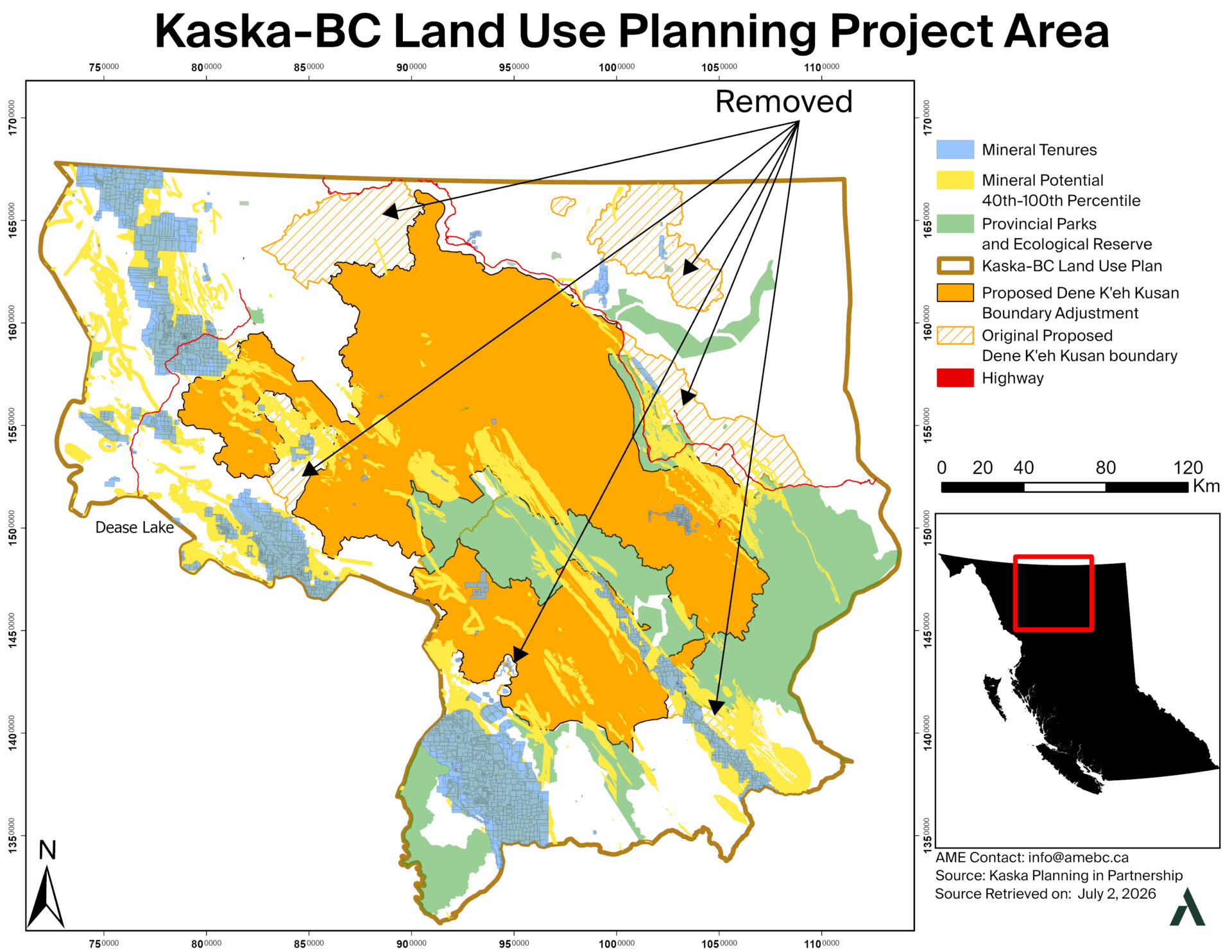
The project scope is focused on two main points: the Dene K’eh Kusan boundary (Figure 1) and the Dease-Liard Sustainable Resource Management Plan (SRMP) (Figure 2).
Last year, the proposed Dene K’eh Kusan boundary encompassed approximately 3.9 million ha with 290 mineral tenures; the government reduced its boundary to 3.1 million ha (215 mineral tenures or 10 mineral tenure holders). According to the government, 193 mineral tenures remaining inside the proposed conservation boundary are subject to agreements with a third party to acquire and relinquish the tenure. The 3.1 million ha is a proposed conservancy under the Parks Act that will be 30×30 compliant.
The Toodoggone mining district is not affected by the proposed conservation area.
The second scope of this project is the Dease-Liard SRMP. The Dease-Liard SRMP is west of the Kaska-B.C. Land Use Planning area, and the management direction of minerals and aggregates is being updated. It includes objectives such as First Nations being active in all phases of the mining life cycle. For more information, you may view their document here.
The draft also proposes updates to the Dease-Liard Sustainable Resource Management Plan, including consultation timelines ranging from 10 to 40 days and a greater focus on targeted areas of high mineral potential.
The engagement is open until August 4, 2026, and can be found on the website link above. If you are a member, please let us know your concerns. We anticipate a “What We Heard Report” and plan refinement in August 2026. The development of final recommendations can be anticipated in November or December 2026.
Meziadin River Watershed Salmon Habitat Conservation Plan
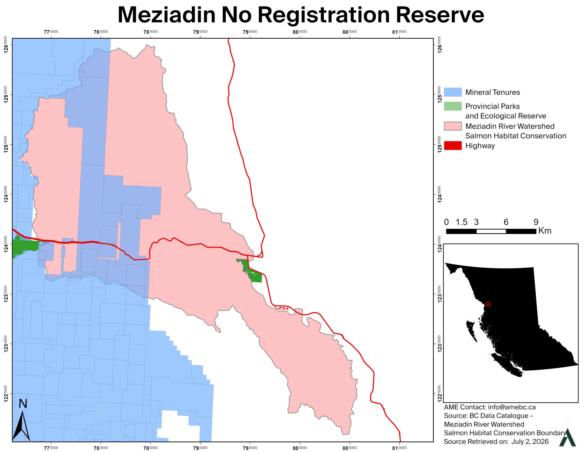
Meziadin follows a similar pattern. Claim holders in the area have largely agreed to relinquish their tenure, and the region is expected to move toward conservation. There will be no changes to the road or use of the region as a major transportation hub is expected. Members impacted are encouraged to share your feedback until August 4, 2026 found on the website link above.
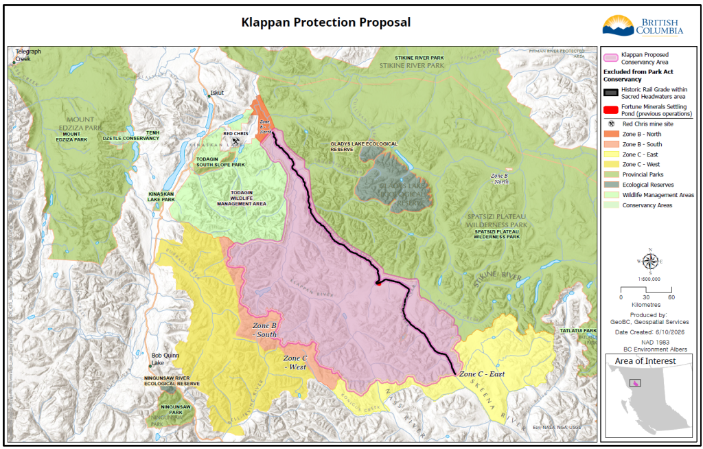
The Klappan Plan was developed independently of the Northwest Land Use Plans through work done over the last decade. It covers approximately 636,000 ha, including 300,000 ha designated as the Sacred Headwaters (Zone A), as a proposed conservancy. The Sacred Headwaters establishes a 20-year prohibition on major industrial activity. All coal tenures have been relinquished and no mineral tenure exists.
Taku River Tlingit First Nation (TRTFN)-B.C. Planning Project
The TRTFN and B.C. government hosted a multi-sectoral workshop in Richmond and Atlin in May. They are seeking feedback on the Supporting Responsible Mining Exploration and Conservation of Sensitive Values Concept Paper, which outlines proposed approaches on information sharing and reporting, environmental management planning, and adaptive management for mineral exploration and mining.
The plan is in phase 3 of drafting plan products, and we are anticipating future engagement opportunities. If you wish to submit comments, please contact [email protected].
Tahltan-B.C. Land Stewardship Planning
The Tahltan and B.C. government hosted a multi-sectoral workshop in Richmond in May, where they shared progress on the planning process and key draft materials. They are currently in the stage of developing a plan. The presentation and key draft materials are available at the link above, along with a Resource Atlas featuring the maps developed to date. Engagement will continue through Fall 2026.