Although scientific research is necessary for successful mineral exploration, little of it is undertaken by mineral explorers themselves. “Academia is where scientific research for mineral exploration takes place,” says Vancouver-based exploration geologist Danae Voormeij. “Breakthroughs are shared with industry at conferences and in scientific bulletins. The sponsors are the major metal producers.”
The Geophysical Inversion Facility (GIF ) at the University of British Columbia is one example among many. GIF director Doug Oldenburg says the facility uses inversion to solve problems relevant to mineral exploration, as well as geotechnical and environmental problems. “Inversion refers to processing data with computer software to obtain an image of the Earth,” Oldenburg says. “For instance, magnetic data can be inverted to find rocks that are easily magnetized, and gravity data can be inverted to determine rock density.”
Oldenburg says geophysical inversion is akin to medical imaging: “CAT scans and MRIs both involve an energy source and a data recording.”
GIF’s main focus is developing computer methodologies and software that generate 3D images of the Earth’s sub-surface from geophysical data. “Each rock has a suite of physical properties,” says Oldenburg. “Knowing the physical properties, or structural relationship of these properties, can help solve geophysical problems. We liaise with companies, identify problems and geophysical data sets, and then develop software to invert these data to construct a 3D image of the subsurface.”
GIF, which was founded in 1989, is led by Oldenburg and Professor Eldad Haber, conducting research in electromagnetics, potential fields and software tools.
Electrical conductivity has applications in many problems in mineral exploration. “The underlying equations are complicated, and large scale computing is needed,” says Oldenburg. “In the last 10 years, we’ve developed the technology to simulate and invert these data. Our current focus is on making the algorithms more efficient and applying them to field data sets.”
The facility is reviewing some of its early work in potential fields research to develop a new generation of software. “For instance, magnetic susceptibility in magnetic surveys can sometimes be very high, and traditional solutions can struggle to obtain a geologically meaningful answer,” says Oldenburg. “The rocks in areas hosting mineral deposits may also be contaminated with remanence. Recognition of these effects and how to handle them requires new methodologies.”
Another area of current research is the development of GIFtools, which is a computer environment for carrying out advanced geophysical inversion. “The major challenge with geophysical inversion is the non uniqueness of data,” explains Oldenburg. “GIFtools allows the user to invert his particular data set while adding other types of information, so that the final inversion is compatible with the geophysical and geological knowledge that is available.”
Also located at UBC is the Mineral Deposit Research Unit (MDRU). Monica Spisar, who is in charge of business development, says MDRU creates knowledge for mineral explorers in the form of data, models and interpretive insights. “MDRU also creates tools to enhance data driven exploration decisions,” Spisar says. “Those tools include exploration techniques, such as footprint techniques for identifying concealed deposits, and devices, including those that expedite sample analysis.”
![Monica Spisar Business Development, Mineral Deposit Research Unit, University of British Columbia | Monica Spisar]()
Spisar says MDRU is different from other academic-industry partnerships because the initiative to create the organization came from industry, which continues to drive its strategic focus. “MDRU enjoys tremendous support from its industry sponsors. That is a key component of our success and relevance.” MDRU has at least two projects dedicated to developing exploration methods to improve the targeting of concealed deposits. “For example, MDRU’s exploration geochemistry initiative and porphyry indicator minerals projects identify signatures for concealed deposits and develop methods to apply these signatures,” says Spisar.
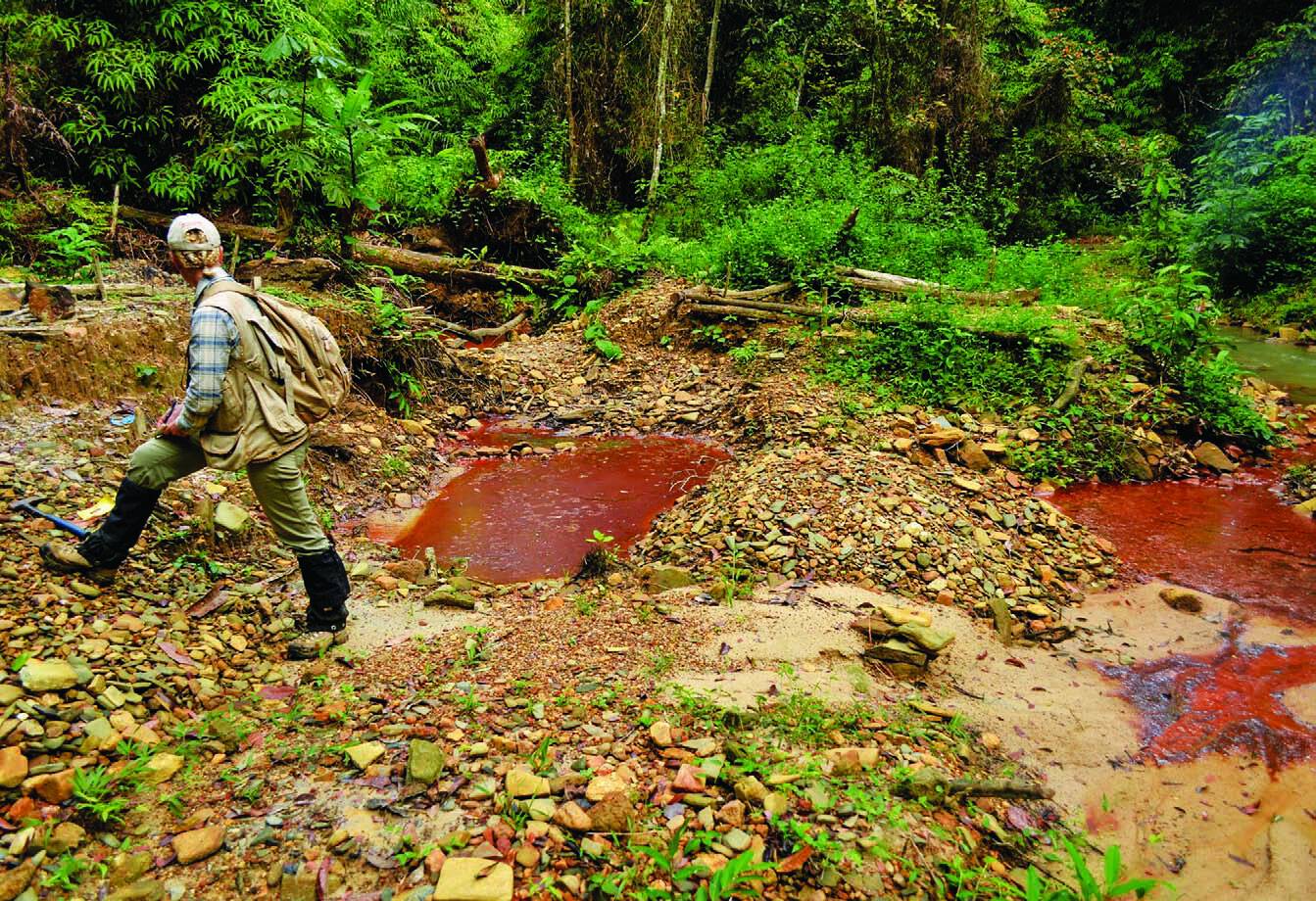
![(Opposite top) Danae Voormeij examines drill core at Hummingbird Resources’ Dugbe project in Liberia | Alexander Lerche]() ![(opposite bottom) Voormeij with local workers | Moses Dennis]() ![(this page) Voormeij in the Liberian jungle | Alexander Lerche]()
Recently, MDRU developed a carbonate isotope analyzer that is an alternative to traditional mass spectrometry for targeting carbonate hosted deposits. “The carbonate isotope analyzer is less expensive, more portable and easier to use than a mass spectrometer,” says Spisar. “It is capable of producing 100 results per day, compared to 10 results per day using a mass spectrometer.”
These are all present-day technologies. But what about the technologies of tomorrow? Danae Voormeij has been putting together a wish list.
“As an exploration geologist active in tropical latitudes, I deal with a thick weathering rind, called regolith, that lies as a layered cover between my feet and a gold deposit at depth,” Voormeij says. Regolith in the tropics is typically about four to five metres thick and includes laterite and saprolite. “Some of the layers contain the critical information that is needed to pick up on the signature of an ore deposit at depth; other parts of the regolith are leached by the groundwater and will be barren if sampled accidentally.”
Voormeij would like to be able to punch through the regolith with a high-tech, lightweight, durable and perhaps even battery-powered hand auger. “It should be able to reach depths of up to 10 or 25 metres quickly, so that we can reach and sample specific layers of the regolith.”
Voormeij is also hoping someone will develop an application of gravity surveying technology to locate ore deposits in the tropics. “For example, at IAMGOLD’s Rosebel Gold Mine in Dutch Guyana, the regolith is 150 metres thick before reaching hard bedrock,” says Voormeij. “With improved elevation precision in global positioning systems, gravity surveying can be used to identify thicker regolith cells along a trend.”
Voormeij says one of the biggest challenges facing contemporary explorers is how to report to head office from the field in real time. To solve this problem, she has come up with a futuristic creation that she has dubbed the Mineral Exploration Mobile Unit (MEMU ). “Like in Michael Crichton’s fictional Jurassic Park and Lost World stories, what I’m thinking of is a set of mobile trailers, complete with office, lab (with a built-in X-ray fluorescence analyzer and a small sample-processing facility), mess, shower/washroom and sleeping quarters, communications software and an on-board cook/medic,” says Voormeij.
“The MEMU would be used in grassroots mineral exploration to collect and analyze field soil and rock and water samples, and apply the results instantly, to make decisions for the next move. And management can observe all this in real time from head office back home.”
The last word on scientific research and technology in mineral exploration goes to John Thompson, former vice-president of technology and development with Teck Resources Limited, and now a consultant and Cornell University professor. He says that for explorers to find new, high-quality ore bodies, they need good technological products and techniques. “Technology can facilitate better real-time decision making in the field,” he says. “When used effectively, it can improve field skills, and thereby maximize a project’s value. But technology by itself can’t do it all.”