Every surficial sample, be it soil, surface sediment or vegetation, tells a story. The challenge in mineral exploration is knowing whether that story belongs in the fiction or non-fiction aisle. As surficial geologists, our job is to help make that determination. An exploration program that properly considers the nature of the overburden – or surficial geology, to be more explicit – invariably saves money and expedites the path to successful drilling. Overburden is a dynamic tool for mineral exploration, yet many exploration geologists do not know how to use it effectively. Unfortunately, it’s still all too common to conduct generic “soil” sampling along a grid without considering the surficial geology. In previously glaciated terrain, these soil grids have a high potential to mislead exploration. Surficial geologists are sometimes completely omitted from mineral exploration projects. But I guess this isn’t that surprising, considering few geology programs offer courses that even touch on the application of Quaternary science to mineral exploration; many geologists finish school without learning how important and complex the implications of surficial geology can be. Without this surficial context, the line between fiction and non-fiction becomes blurred.
Surficial samples are commonly used as a foundation to direct geophysics and drilling programs. My colleagues and I have spent a lot of time in the field and have seen firsthand how the quality of surficial exploration data can influence the success of a program. It is essential that the surficial exploration data are reliable or the project will be at risk of costly mistakes. We’ve had the pleasure to meet and learn from a lot of clever geologists. If we’ve done our jobs correctly, they’ve also learned from us. Working together, we’ve witnessed the “aha moment” when the importance of understanding the surficial setting really hit home. Some of these moments lead to exciting stories where an important tool was added to someone’s mineral exploration toolbox, and others were unfortunate tales of deception.
Let’s start with a historical fiction about diamond exploration in the Lac de Gras region of the Northwest Territories. The client had been following a poorly defined dispersal of indicator minerals in till. There were subtle patterns apparent in the vintage, washed-out air photos, but it was difficult to determine if or how the dispersal definition was related to these patterns. So, off we went to investigate.
Courtesy David Sacco
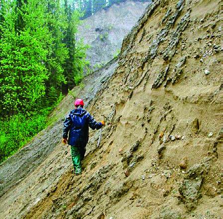
After breaking one of our only two shovels, we cautiously proceeded to characterize gravelly diamicts, conspicuous mounds of poorly sorted sediment and outcrop-scale evidence of fluvial erosion. It became clear that predictable pathways were reworked by meltwater. The area was generally mantled by till, as indicated in the regional mapping, but this existing mapping did not identify the subtle processes that affected the till after deposition. Armed with field-verified calibration points, we re-examined the air photos, delineated the areas affected by meltwater and filtered out the reworked till samples.
The resulting dispersal was better defined and provided a better understanding of the source area. Our clients learned that not all till is “good till” and that it’s important to consider subtle differences in sample media that may affect their comparability. We learned that conventional surficial mapping protocols did not provide all the information necessary to inform exploration. Going forward, we would tailor our surficial geology interpretations to include the unique characteristics of each surficial environment that can affect exploration.
Now a mystery story about soil sampling. To be clear, we’re referring to sampling near-surface soil horizons with the expectation that the results are comparable and/or indicate mineralization in underlying bedrock. This common default approach to sampling and interpretation is a direct detection method carried over from regions like Australia or Argentina where soils and soil anomalies have developed over hundreds of thousands of years. Unfortunately, the soils in previously glaciated terrain are typically too young, and the materials too complex, for this method to be effective.
A recent example of this comes from a gold project in northern British Columbia. After a series of unsuccessful drilling campaigns, the client asked us to visit the site and review the soil sampling program results. We investigated several sample sites with the client and discussed the different materials and their varying potential for soil development. We then talked about the fundamental differences between anomalies that are displaced due to clastic transport and those that occur directly over mineralization. It was the same old story – the soil sampling program simply followed the classic exploration model, which yielded unreliable targets. Our subsequent work provided a foundation to distinguish samples that underwent clastic dispersal from those with direct-detection potential. It also filtered out samples for which a source could never be accurately identified. A re evaluation of the data using this surficial context revealed several of the previous targets as false anomalies.
Lastly, a parable about surficial geology and exploration. An established company with talented geologists was running a remote till sampling program following up several anomalous reconnaissance surface sediment samples. While crews were out filling hundreds of sample bags, our team headed toward the three anomalous sites that spurred the follow up survey and our project involvement. En route to the survey area, we could see that glacial meltwater had significantly altered the landscape. The first anomalous site was a lag deposit within a large meltwater corridor. The second anomalous site was a paleoshoreline from a glacial lake that had long-since drained, and the third was an esker fragment.
This complex terrain was full of materials that had similar characteristics to till, and the geology students hired to conduct the reconnaissance sampling did not have the experience to differentiate these materials. In the end, the expensive program was based on misleading data and culminated in no exploration targets. A preliminary investigation of the surficial geology could have identified that the reconnaissance samples only appeared anomalous because they were assumed to be till.
It seems obvious in this neatly laid out op-ed that overburden may not be the burdensome villain its common name suggests, and that it is deserving of more consideration in mineral exploration. But the implications of surficial geology for mineral exploration simply aren’t taught in sufficient detail as part of the standard geology curriculum for this consideration to be part of the normal procedure. In two of the three experiences we presented, unravelling this complexity saved our client time and money by leading the exploration program in a more successful direction. The third story is an unfortunate reminder that, without the proper context, the story of your surficial exploration data may belong in the fiction aisle.